Fort Baldwin – A Piece Of Maine’s Military History

img_1789

I recently visited to document Fort Baldwin in Popham Beach, ME. For those going down to take a look this is a lengthy drive down the penninsula. The site is extremely well preserved and one can walk through almost all of the buildings to explore. Sadly the fire tower was not open at the end of the path. Here is a Wikipedia roundup of it………….

Fort Baldwin, a coastal defense land battery near the mouth of the Kennebec River in Phippsburg, Maine, United States, was named after Jeduthan Baldwin, an engineer for the Colonial army during the American Revolution. The fort was constructed between 1905 and 1912 and originally consisted of three batteries, all of which were removed in July 1924:

  • Battery Cogan with two three-inch guns. Named in honor of a lieutenant in the 5th Continental Infantry during the American Revolution. Cogan, who had also been quartermaster of the 1st New Hamsphire Regiment, died August 21, 1778.
  • Battery Hawley with two six-inch pedestal guns. This battery also housed the fort’s original observation station and electric equipment. Named in honor of Brigadier General Joseph R. Hawley who served with distinction during the American Civil War.
  • Battery Hardman with one six-inch pedestal gun. Named in honor of a Captain in the 2nd Maryland Regiment, Continental Army during the American Revolution. Hardman was taken prisoner at Camden, South Carolina and died while a prisoner of war on September 1, 1780.

During World War I, Fort Baldwin and Fort Popham held a garrison of 200 soldiers including the 13th and 29th Coast Artillery.

During World War II, between 1941 and 1943, D Battery, 8th Coast Artillery protected Fort Baldwin and its Fire Control Tower that could radio the precise position of enemy vessels to batteries in Casco Bay.


Boobytown

For some time now I had the knowledge of a mysterious part of Maine’s varied history, this time from Lewiston. I lived almost my entire life in the tri-state region of Massachusetts so upon reading this story I never acted on actually going for an actual visit. I cannot even tell you now that I have been there, I haven’t. What I can tell is the unusual stigma attached to a village in Maine by the name of Lower Dallas.

In the mid 1800’s the prosperous city of Lewiston in Maine had an innovative and at the same time bastardy plan at the same time. The roll call for welfare was quite large during this period. The city needed a way to turn the tide of people depending on the system. Someone, I do not know who, came up with the idea with shipping them off to what is known as Lower Dallas just east of Rangely in the northwest corner of the state. These people were hard up while living in Lewiston and after the move to Lower Dallas things only got worse. Stories of people running off into the fields to eat dandelions raw were the norm. Of all of these welfare afflicted Lewstonians the most prominent family was the Bubiers thus the towns name of “Boobytown” came into being.  The Boobytowners were always known by the people of Rangely as honest and fair trading partners and always had the utmost respect for them. Sad that such a quality of people was shipped away in favor of saving a few dollars (in today’s money mush more).

Today if you can find the way to the location of Lower Dallas you will find a virtual ghost town, complete with newspapers from the period around WW 2 on the floor of some of the structures. It is in these ways that Maine is trully unique as if someone leaves the forest locks it up until later discovery. Last heard, the is only one descendant of the Bubiers still living near Boobytown, Virgil Bubier. If anyone is looking to go there I hear he is one of the best people out there with the history of the place.  It’s an understatement to say that a general feeling of paranormal activity also prevails here according to reports, which can only be imagined with the history of these people stolen from their home. I hope in the future more attention can be brought to this incident in Lewiston’s history and the whole state of Maine in general. I can only hope this article keeps alive the drive for people to find out more about it.

I want to give special credit to Art Sordillo and Yankee Magazine for this other, somewhat related article, definitely a good read.

http://www.outtakes.com/45th/45thnopics.html

The Enigma Of Bancroft Tower

cfiles10420

In the middle of Worcester, Massachusetts lies a remarkable oddity. A “lite” castle or tower as it is refered to sits in the middle of a park. The only way to describe the structure is that you imagine a castle and then imagine it 2d. It has very little depth and mimics a Hollywood prop castle. The unique history with which is attached to it is really quite interesting as well.

The tower was built in 1900 to honor George Bancroft (1800-1891), he was Secretary of the Navy,Founder of the U.S. Naval Academy, U.S. Minister to Great Britain and Germany. Quite an accomplished man. This was to be his legacy. A tower that when the true “tower” was open afforded a 360 deg. view of Worcester. This memorial was built by his friend and admirer Stephen Salisbury III. Thanks to the City Of  Worcester Parks And Public Works Website they offer a quite inclusive history.

“The Bancroft Tower was built by public benefactor Stephen Salisbury III, who bequeathed it to the Worcester Art Museum, which deeded it to the Parks Department in 1912.  Salisbury intended the feudal-like castle to be a recreational oasis. Its spiral staircases, fireplace chambers, stone benches, and parapets were frequently the scene of picnics and social outings. The summit has a 360-degree view of the city,  greatly enhanced by a climb to the lookout tower. A locator map in the stone walkway helps to identify the distant hills. George Bancroft was a politician, statesman, and writer. His list of achievements is exceedingly long, ranging from cultivator of the American Beauty Rose and eulogist at Abraham Lincoln’s funeral, to Secretary of the Navy (founder of the U.S. Naval Academy at Annapolis) and author of a scholarly ten-volume history of America. But, Stephen Salisbury III built the memorial to Bancroft because Bancroft and Salisbury’s father had been childhood friends. A plaque marks Bancroft’s birthplace just below the park on Salisbury Street.

Honorable Stephen Salisbury III became a member of the Parks Commission in 1887.  Mr. Salisbury owned a great deal of land in the northern part of the city and was always eager to improve that section. He was involved in the donation and development of a plot of land on the south side of Salisbury pond soon to be named Institute Park. Initially Stephen Salisbury set aside 20 acres of land along Massachusetts Avenue which included Bancroft Hill.

In 1900, he erected a tower on the summit of this hill to honor George Bancroft, the famous historian whose birthplace was just below on Salisbury Street.  The tower is 56 feet high and is constructed of boulders, cobblestones, and is trimmed with a rock-faced granite.  It looks like a miniature feudal castle.  The construction cost was about $15,000.  Stephen Salisbury opened it to the public during this time. Some of the finest views in the City could be seen from this tower.  It is named on the National Register of Historic Places.   When Mr. Salisbury died, this property was bequeathed to the Worcester Art Museum who in turn presented it to the City in 1912.”

The true enigma may be actually the stories of hauntings and the marks carved in stone placed in the ground the “supposedly” pointing to the seven hills of Worcester. The lines actually dont point to the hills and are quite confusing. Many believe they are actually ley lines across the earth that intersect at the point of the tower. One can only believe that if someone took the time to carve them in stones they must represent something. But what?


My August Expedition To The Ram Tail Mill Site, Rhode Island’s Only Officially Haunted Site

13712405

In August of this year I visited the Ram Tail Mill Site in Foster, Rhode Island. According to the Source: Belanger, Jeff. Encyclopedia of Haunted Places. 2005, “

“Perhaps the oldest and most haunted place in Rhode Island is the Ramtail Factory in Foster. It was even put in the 1885 State Census Record as a haunted location. In 1799, the Potter family started operating a mill. William Potter expanded the mill in 1813. At this time, William took his son-in-law Peleg Walker as a partner. The Potter’s ran the mill by day and Walker was the nightwatchman at night, walking from building to building with his lantern.

This went well for several years, until one day Walker and Potter were seen having an argument. Walker preceded to say that if something kept up, he’d walk in one day and grab the keys from a dead man. On May 18, 1822 Walker’s words came true. Potter walked in and saw that Walker had hung himself from the bell rope with the keys hanging visibly from his pocket. The Potter’s then buried him in the family plot. However, this is when the strange events started to happen.

The night of Walker’s death, the bell tower struck at the stroke of midnight. The Potter’s went to go investigate this but no one was there pulling the chord while it was happening. This went on for a few days until the Potter’s then replaced the bell with a new one. Now it got even more interesting that night. The town awoke to the loud sound of the mill running at full service. Everywhere in the town went to the spot to watch in shock as the mill was running without anyone operating it, and the water was flowing in the opposite direction of the stream.

Most of the town villagers left after this for fear of the mill. The people who remained in the town would see the apparition of Walker going from building to building with the lantern in his hand. Later on in the 1880s, the factory mysteriously went on fire. The remains of the factory still lie in the woods of Foster to this day, and is a hot bed for paranormal activity. The Rhode Island Paranormal Group investigated the site recently and have come into contact with Walker as well. They were standing around the site, when they the crunching of leaves and the sound of a lantern swinging as it walked past them and into the main building.”

The day we went ( my wife and I) it was quite hot and humid. It was the beginning of the fall season that I do the majority of my exploring in. We arrived early and took the entrance to Ram Tail Rd. Directly after the right there is a cemetary on the left. The relatives of the mill descendants are buried in this plot.  After the cemetery on the left side there is a dirt road which leads into the woods and runs toward the lakeside of Barden Reservoir. I parked our trusty mini-van(giggles to a minimum) in a pull-off of the trail. We followed the trail  towards the location of the site. As we came to the true North side of the reservoir we reached a point where a bridge or crossing had once been, unfortunately it was unavailable.  We had to find a way across and it was not going to be there. The water was far to deep. To make a long story very, very short we found a spot farther North on the river that feeds in to the reservoir. Logging seems to be in full swing all arond the area at this point. I saw tree’s cut all around the original foundations but all the area of the mill site is really quite protected. Blue marks denoted cut lines that indicated the trees inside the foundations were not to be touched. Im glad to report a trouble free visit and quite an interesting one (wading in 2 feet of water across a river). My wife would not go in the main foundations and had a bad sense of something not right in the area. I experienced none of those things just a calm and peacefull visit. Altough I wouldnt want to be visiting in the dark………

Highly interesting video supposedly shot in the ghost town of Dudleytown, CT

I came across this video a couple of months ago and I still think back to it now and then. The shadow in the later part of the video is the obvious spook but my wife feels there is yet another occurrence happening around the same time on the video. The guy narrating is definitely was a British citizen at one time which raises the question of the validity location of the video. Britain or Connecticut? Not that the British don’t live around us, just too many loose ends. I don’t know what to make of it but its so damn intriguing. If it is real I wonder how many of these “shadow people” are really out there. Check it and comment on what you think.

Waypoint Map Of Oddities and Ghost Towns Of New England On Google Maps

I created this map back in August of this year. It has 113 places in the greater New England area that are really worth a visit, at least some due research. I have visited at least half of the sites on the map and am trying to finish off Southern New England before my departure for Maine and the North Country. I hope with the best intention that people visit these places with great respect and please help maintain these great sites. If you see any litter please pick it up. It takes only one person to make a difference. Thanks everyone and enjoy!

Pictures From The Ghost Town Of Bara Hack, Pomfret, CT

In August of this year my exploratory team and I took a trip south to Pomfret, CT to see the much fabled ghost town of Bara Hack. It was a early Welsh settlement that was abandoned in the early 1900’s. Here is an excerpt from barahack.com –

“The name “Bara-Hack” is associated with Harry Chase, a local Pomfret historian/recluse who claimed the village was so named.  There is no evidence that the Higginbothams named their little two home village “Bara-Hack”.  It sounds more scary than the “Higginbotham’s abandoned settlement” though.  Using a Welsh to English language converter: bara= bread, drylliad= breaking, torri= to break, tor= break, and hac=cut, notch, or hack.  Thus Bara Hac=cut bread.  The Higginbothams were of Welsh descent so they must have “cut bread” there, but most likely would not have named their settlement Bara Hac.

On August 30th, 1971 three Rhode Island parapsychology students visited “Bara-Hack” looking for evidence to verify whether or not the rumors of its’ haunting were true.  They met with Harry Chase and went to the Lost Village. They encountered the following: a sense of depression when entering the area, constant barking of dogs, lowing of cows, strange human voices, and a complete absence of birds.  They explored for a couple of hours and came back at night.  They heard spooky voices coming from the Nightingale Brook.  They came back October 30th and 31st with more investigators.  They lost their way walking towards the burying ground even though they had been there before.  One of their new team members became frozen in place on the trail and could not be physically moved by anyone there towards the direction of the cemetery.  One of the investigators wrote about the experience in a book called Faces at the Window, Paul F. Eno, 1998. The premise for the Blair Witch Project is thought to come from the accounts of this “investigation”.

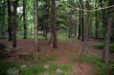
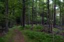
The Lost Village or Bara Hac is located in a hilly area surrounded by many brooks and streams, voices and other sounds carry for miles in these areas.  There are still even today working dairy farms and hobby farms in Pomfret which is part of the Last Green Valley.  Pomfret is a rural area and as such almost everyone has dogs and other animals.  Since much of Pomfret and Windham County is a National Heritage Corridor and the Last Green Valley much of the land is protected from development.  There are coyotes, fisher cats, bobcats, black bear, and recent sightings and tracks from mountain lions.  A common sign of a predator being in the area is an absence of normal forest noises, a strange stillness devoid of sound.

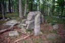
The Lost Village is located on private property and may soon be open to the public because there is such an interest.  The area is currently being logged and the forest thinned out.  You still need permission to go there, and I suggest not going as the area is closely watched.  There are no town police in this part of Connecticut, but there are plenty of shotguns.  The owner has written a book based on her own research into the Higginbothams life and death in Pomfret.  The Lost Village of the Higginbothams, Doris B. Townshend, Vantage Press, NY, 1991. The book is a historical fictional novel based on  facts the author was able to uncover and is a good fast read that provides an intimate look into 18th and 19th century rural colonial life.

I am a Pomfret resident and have been to Bara Hac many times including after sunset and have never encountered anything unexplainable.  My family came over on the Mayflower in 1620, and has lived in the Eastern part of Connecticut since 1637.  I have spent a good portion of my life exploring the New England forests and countryside.  Even scarier than Bara Hac… I live on Pomfret’s very own Witches Hill.  Suspected witches were put to death in Connecticut before the Salem Witch Trials ever happened.  Unfortunately, nothing even remotely paranormal has happened here either.  ”

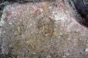
I managed to get some great pictures and was intrigued by the place and its tranquility. Quite a remarkable place. Especially the face carving on the rock. Again from Barahack.com –

“Such stone carvings are called petroglyphs by archeologists.  Many of these stone carvings have been found out west in Indian territory, and are thought to have been carved thousands of years ago.  Others were found to be of more recent Indian history of 200 to 300 years ago.  The age of a carved stone is it’s biggest mystery.  Some carvings are signify sacred sights, and tributes to great spirits of long ago.  Other carvings have been found near burial sights, and as tributes to ancient leaders.  Others may simply be directional markers. ”

Here are the pics……